
| PHYSICAL AQUATIC
HABITAT |
|
DEFINITIONS AND DIVERSITY
Habitat is the place or environment where a plant or animal naturally or normally lives and grows. "Environment" here implies the sum total of all influences within the living space of a plant or an animal. For fish, habitat includes the stream, its boundaries (bed and banks), existing vegetation, and other animals. Physical factors such as water depth, velocity, cover, and bed material are referred to as physical habitat. In fact, these four factors are most often used to describe physical aquatic habitat. Streams tend to provide complex, dynamic physical habitat. For example, water depth and velocity vary continuously in time and space. Deep, slow pools lie adjacent to swift, shallower runs and riffles. Bed material, although slightly less dynamic than depth or velocity, also varies to produce a high level of spatial and temporal heterogeneity. The high level of physical diversity typical of natural (lightly impacted by humans) streams provides niches for many types of plants and animals, and thus supports relatively high levels of biological diversity.
Human influences often result in simplification of stream habitats, making them more uniform and adversely impacting biological communities.| Meandering streams with deep pools on the outside of bends and gravelly riffles at thalweg crossings (inflection points) between bends are often straightened and channelized to improve alignments for bridges or highway embankments. Sinuous channels with a non-uniform cross section are sometimes altered to become a prismatic trapezoid, and pool-riffle sequences are commonly replaced with uniform runs. Woody debris, an essential component of many habitats, is usually removed or displaced as riparian vegetation is removed and banks are either cleared or stabilized. However, it is important to note that the spatial heterogeneity typical of natural streams is not random. Specific patterns occur that are essential for various populations. | 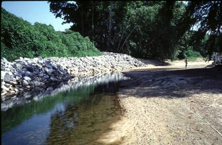 Figure 1. Stone toe provides stable benthic habitat and cover for smaller fish, but little diversity or pool habitat. |
For example, swift waters immediately adjacent to eddies and regions of depressed velocity allow some organisms to obtain food with minimal expenditure of energy. An engineer could design a stream with a checkerboard pattern that would be physically diverse but ecologically barren since natural patterns would not occur.
Lotic (moving water) ecosystems also depend on temporal patterns. Human activities
tend to perturb natural hydrographs, either exaggerating extremes or making
them more uniform by removing flood peaks and elevating base flows,
as is the case with reservoirs. Urbanization and other types of watershed development
often increase the fraction of precipitation that reaches the stream channel
as surface runoff.
This makes flood peaks higher and sharper, but depresses base flows and effective
precipitation since less of the total precipitation infiltrates to into the soil
profile or aquifer, which supplies the base flow. Occasionally, human impacts
are extreme enough to cause a stream to regress from a perennial to seasonal
in duration.
HABITAT SCALE IN TIME AND SPACE
The design of erosion countermeasures typically focuses on the hydraulic and structural properties of a relatively short reach during higher flow periods when boundary shear stresses are at a maximum. Consideration of aquatic habitat, however, requires a much larger scale of reference both in time and space. Fish (and most other organisms specialized for life in river systems) are highly mobile creatures that live out their lives in a series of places (habitats) which can be separated by up to 100 km (60 miles) of river channel. Fish ecologists typically partition these habitats into basic types such as feeding habitats, resting habitats, spawning habitats, and nursery habitats. Each type has relatively distinct hydraulic and structural properties. Many fish populations are limited by the quantity or quality of one or more of these habitats, or by the lack of connectivity between key habitats. While it is unlikely that a fish population would ever be entirely dependent on the relatively small areas typically affected by the installation of a single erosion countermeasure, opportunities for increasing either the amounts or quality of fish habitat could potentially pay high dividends both for the environment, and in terms of public appreciation and resource agency approvals.
Large-scale channel restoration or stabilization work (directly affecting a reach longer than 20 channel widths) could have major effects on an aquatic community. The design of erosion countermeasures typically requires a focus on high flow hydraulic conditions. This is entirely reasonable because erosion processes are usually limited to (or maximal at) high-energy events. Habitat design, however, must again take a wider view because fish live in their habitats at all times of the year and are affected by both high and low flow hydraulic environments. The habitat implications of a particular erosion control or habitat improvement technique can be quite different during high flow and low flow periods. |
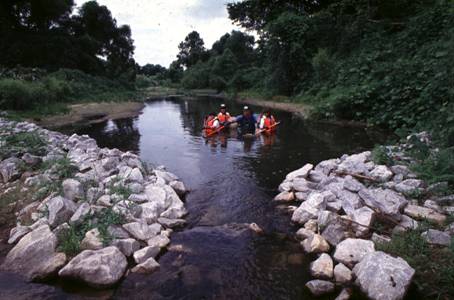 Figure 2. Weirs can create pool-riffle habitats and help stabilize beds, but should be designed carefully in streams with low bed slope to prevent eliminating current during low flow. |
WATER TEMPERATURE
An important first step towards environmentally-sensitive design is to recognize
that water temperature and site spatial context (with regard to both landscape
and river network position) do more to shape the basic structure and productivity
of fish communities than local physical features. Because fish and their food
organisms are cold-blooded, growth and productivity rates always vary strongly
with temperature. Typically, both increase with rising temperature until a physiological
maximum is exceeded. Thermal optima vary between species, but fisheries managers
often make a basic distinction between sites and their fish communities based
upon the thermal tolerances of the dominant species present. "Coldwater
streams",
for example, are dominated by a few species such as trout and salmon that have
rather low thermal optima. "Warmwater streams" are dominated by a
larger number of species such as sunfish and suckers with higher thermal optima.
In between these extremes, scientists recognize coolwater systems where members
of both groups (and other fish with intermediate thermal preferences) may
coexist. Water temperature in these transitional sites is an extremely important
variable, since small changes in one direction or the other can cause tremendous
alterations in the composition and productivity of the fish community. This
variability in thermal setting directly affects the ecological value of more
local habitat features like shade and groundwater inflows.
GEOMORPHIC CONTEXT
The landforms and hydrology of the upstream watershed directly affect the
water temperature and the water and sediment flow regimes that govern habitat
quality of a specific river reach. The details of linkages between climate,
landscape position, fluvial geomorphology and hydrology are very complex. Simply
put, however, the flow regime interacts with the physical structure of the
channel to produce physical aquatic habitat we characterize in terms of depth,
velocity, substrate composition, etc. For example, coldwater streams tend to
be steeper, found at higher elevations, and have coarser bed material (gravel,
cobble and boulders) than warmwater streams.
HABITAT ISSUES AND OPPORTUNITIES
High Flow Issues
Velocities| Inundation of floodplains during high flows provides large areas of refuge, but also facilitates a host of other ecological functions, particularly along larger rivers where flooding durations are measured in days or weeks. For example, fish feed on terrestrial plants and animals (insects, earthworms, etc.) trapped by rising floodwaters. Receding floodwaters carry organic matter back into the riverine ecosystem for additional cycling and spiraling. In order to spawn, some species of fish are dependent on the low-energy habitats found on flooded, forested floodplains. Isolation of floodplains from the stream by channel incision, channelization, levee installation, or other forms of structural flood control can be detrimental. |
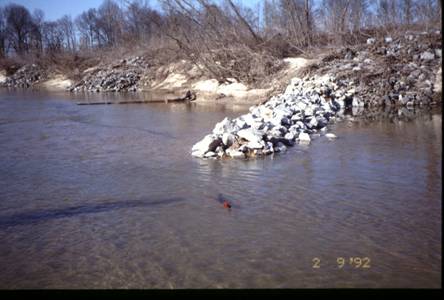 Figure 3. Spurs, barbs, and bendway weirs provide local zones of low velocity that are effective refuge. |
Local bank erosion and sediment loading / transport
Localized bank erosion is often identified as detrimental to fish habitat, usually because it is thought that the eroded sediments may fill pools or cover gravelly riffles downstream. Actual effects of local bank erosion vary based on the overall sediment balance within the watershed and reach. Bank erosion is not necessarily problematic from a habitat perspective; likewise, every bank stabilization project is not necessarily a habitat improvement measure. In some rivers, gravel and cobble riffles require eroded material from banks to replace downstream transport. In other reaches, flow energy is sufficient to transport sediments from eroding banks through the reach with little or no accumulation.
Of course, there are many river systems in which bank erosion can lead to
habitat deterioration; for example, when low flow deposition (see below) is
particularly problematic, spawning substrate (coarse bed material) is in critically
short supply, or erosion and transport of sand banks contribute to a lack of
deep pools and hydraulic diversity in the reach. In these settings, almost
any form of bank stabilization might have habitat benefits, provided the design
does not adversely affect other aspects of habitat quality.
Planform and other large scale channel adjustments
Systemic
erosion associated with lateral migration or other
forms of channel adjustment occurs when there is a large-scale disequilibrium
between water and sediment loads, channel shapes, and slope. Under these
conditions, extensive bank erosion, bottom scour, sediment transport,
and downstream bed aggradation usually occur, more or less simultaneously,
across large sections of the channel network. Causes for systemic erosion
vary, but frequently involve natural climatic variations, human alterations
of watershed hydrology, or changes in the channel base level or other
downstream hydraulic controls. In such situations, high flow erosion
is evident, and biological communities are often heavily impacted.
Streams in urbanizing watersheds frequently suffer from these effects,
compounded by deteriorations in water quality and low flow dewatering.
Opportunities for habitat enhancement in these settings are minimal
without addressing the underlying issues. Erosion countermeasures are
difficult to design, implement and justify in such a setting. Watershed
management is typically the most effective scale for corrective measures.
Low Flow Issues
Design considerations for protecting habitat quality during low flows and
mitigating high flow erosion can be quite divergent. Environmentally sensitive
erosion protection should include a careful review of habitat impacts during
summer and fall when habitat quality is typically limiting the reproduction
and growth of both adults and juvenile fish. Low flow magnitudes vary widely
from site to site, adding further complexity.
Velocity constraints on metabolism and feeding
During periods of base flow, stream water velocities usually do not produce biologically detrimental levels of shear and drag forces. However, many riverine organisms depend upon the transport of food to their relatively stationary feeding habitats. For example, in both filter-feeding insects and drift-feeding fish, rate of food capture increases (up to a limiting maximum) with increasing flow velocity. Furthermore, the relatively slow rate of molecular diffusion in water frequently limits physiological uptake of essential inputs like oxygen, and dissolved nutrients (for plants). As a result of these mechanisms, excessively low velocities (viz. behind a weir) can be as detrimental to aquatic habitat quality as excessively high velocities.
Erosion countermeasure design for low flow habitat quality includes emphasizing
techniques that do not increase low flow roughness elements or decrease low
flow hydraulic radius. Two-stage channel designs can be a useful way to mimic
natural channel configurations by providing a relatively high radius compact
channel for low flow, and a larger, but lower radius cross-section during high
flows (as observed naturally occurring in valley floodplains).
Cover from predators
Fish populations generally suffer high rates of mortality throughout their life span; visual predators, typically birds, other fish, and humans, inflict the bulk of this mortality . It is not surprising then that most species of fish show a strong attraction to structural elements that obscure the vision of potential predators and provide a complex hunting stage that might favor escape by the victim. Fisheries biologists use the term cover to very broadly refer to any physical structure that might provide such refuge, including pools, undercut banks, submersed living vegetation, and woody debris. During low flow periods, much of the cover near the margins of the streambed may be exposed and unusable. Likewise, pools may become too shallow to provide cover at low flow.
Design features that address needs for increased low flow cover include using
instream structures that promote pool formation (e.g., Boulder
Clusters, Spur
Dikes, Stone
Weirs,
etc.) or constructing channels with low flow channels that contain some deep
pools. Installing measures that increase pool cover in slowly moving streams
must be weighed against potential reductions in flow velocity.
Bed Composition
Stream bed material is an important component of physical aquatic habitat. Key aspects of bed material include its size distribution, how frequently the particles move, and how open the interstitial spaces within the particle matrix are. In general, the diversity and abundance of aquatic insects are lowest for frequently shifting sand beds and highest for cobble and gravel beds that have a wide gradation. When finer sediments deposit within gravel or cobble matrices, water circulation and oxygen supply to the areas beneath the surface of the bed are impeded or eliminated. These habitats are extremely important for incubating eggs of fish, like salmon, that spawn in gravel and for many species of insects (benthic macroinvertebrates). Sandy beds typically support lower densities of all but the smallest invertebrates, and stable objects such as woody debris, clay outcrops, or stone may be heavily colonized by invertebrates in sand bed streams. IMPLICATIONS FOR DESIGN Designing erosion countermeasures in an environmentally-sensitive way means that design decisions are made in light of the larger ecological context of the site. "Ecological context" means the sum of the physical constraints and the relevant biological constraints. When proposing hydraulic and structural modifications, either to abate erosion or improve biological habitat, solutions should be chosen in light of the specific hydraulic and ecological processes relevant at the site of interest. In other words, designs should be ecologically tailored to the site. |
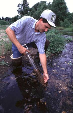 Figure 4. Stable gravelly riffles that are free of fine material typically support rich communities of aquatic invertebrates. |
Some basic habitat improvement issues and opportunities are described above and identified by the Greenbank decision support tool; however, most engineers will find consultation with regional fisheries management agencies a useful step in gathering information about ecological context, and in identifying which habitat management goals might be consistent with the engineering goals of a particular project and ecologically appropriate for the site. Bed and bank protection techniques that have potentially positive effects on physical habitat resources are listed in the table below.
TABLE 1: Bed and bank protection measures that benefit aquatic habitat. 2 = potentially significant impact, 1 = potentially minor impact, 0 = no impact.
| Technique | Provides benthic habitat |
Contributes to bed stability |
Reduces sediment deposition |
Creates or maintains pool and riffle habitat |
Provides cover |
Provides fish rearing habitat |
Provides holding areas for adult fish |
Provides velocity refugia |
| Spur Dikes | 2 |
0 |
0 |
2 |
2 |
2 |
2 |
2 |
| Vanes | 2 |
0 |
0 |
2 |
2 |
2 |
2 |
2 |
| Bendway Weirs | 2 |
0 |
0 |
2 |
2 |
2 |
2 |
2 |
| Stone Weirs | 2 |
2 |
0 |
2 |
1 |
1 |
2 |
2 |
| Vanes with J-Hooks | 1 |
0 |
0 |
2 |
2 |
2 |
2 |
2 |
| Cross Vanes | 2 |
1 |
0 |
2 |
1 |
1 |
2 |
2 |
| Vegetated Earthen Spurs | 0 |
0 |
0 |
2 |
2 |
2 |
2 |
2 |
| Large Woody Debris Structures | 1 |
0 |
0 |
1 |
2 |
1 |
2 |
2 |
| Longitudinal Stone Toe with Spurs | 2 |
0 |
0 |
1 |
1 |
0 |
2 |
2 |
| Boulder Clusters | 1 |
0 |
0 |
0 |
2 |
2 |
1 |
2 |
| Meander Restoration |
1 |
1 |
1 |
1 |
0 |
1 |
1 |
1 |
| Rootwad Revetments | 1 |
0 |
0 |
0 |
2 |
1 |
1 |
1 |
| Newbury Rock Riffles | 2 |
2 |
0 |
2 |
0 |
0 |
0 |
0 |
| Longitudinal Stone Toe | 2 |
0 |
0 |
0 |
1 |
1 |
0 |
0 |
| Cobble or Gravel Armor | 2 |
0 |
1 |
0 |
0 |
1 |
0 |
0 |
| Vegetated/Modified Riprap | 2 |
0 |
0 |
0 |
1 |
0 |
0 |
0 |
| Soil and Grass-Covered Riprap |
2 |
0 |
0 |
0 |
1 |
0 |
0 |
0 |
| Coconut Fiber Rolls | 0 |
0 |
0 |
0 |
1 |
0 |
0 |
0 |
| Vegetated Gabion Basket | 0 |
0 |
0 |
0 |
1 |
0 |
0 |
0 |
| Live cribwalls | 0 |
0 |
0 |
0 |
1 |
0 |
0 |
0 |
| Vegetated Mechanically Stabilized Earth | 0 |
0 |
0 |
0 |
1 |
0 |
0 |
0 |
| Live Siltation | 0 |
0 |
0 |
0 |
1 |
0 |
0 |
0 |
| Live Brushlayering | 0 |
0 |
0 |
0 |
1 |
0 |
0 |
0 |
| Willow Posts and Poles | 0 |
0 |
0 |
0 |
1 |
0 |
0 |
0 |
| Trench Fill Revetment | 1 |
0 |
0 |
0 |
0 |
0 |
0 |
0 |
| Vegetated Floodways | 0 |
0 |
0 |
0 |
0 |
0 |
0 |
1 |
| Vegetation alone | 0 |
0 |
0 |
0 |
1 |
0 |
0 |
0 |
| Live Staking | 0 |
0 |
0 |
0 |
1 |
0 |
0 |
0 |
| Live Fascines | 0 |
0 |
0 |
0 |
1 |
0 |
0 |
0 |
| Live Brush Mattresses | 0 |
0 |
0 |
0 |
1 |
0 |
0 |
0 |
| Vegetated Articulated Concrete Blocks | 1 |
0 |
0 |
0 |
0 |
0 |
0 |
0 |
| Vegetated Gabion Mattress | 0 |
0 |
0 |
0 |
1 |
0 |
0 |
0 |