LITTLE TOPASHAW CREEK

LITTLE TOPASHAW CREEK |
|
Project Name: Little Topashaw Creek
Client/Project Owner: Project was constructed by USDA-NRCS with local soil and water conservation district (Chickasaw County, MS) as the sponsor. This project is part of a multi-faceted research effort by the USDA Agricultural Research Service National Sedimentation Laboratory.
Project Designer: Doug Shields, Jr. of the National Sedimentation Laboratory prepared conceptual design, and Mr. Steve Wilson, USDA-NRCS prepared plans and specifications.
Technique(s) Demonstrated: Large Woody Debris Structures, Willow Posts and Poles
Geographical Location: The study site is located along 2 km (1.25 miles) of Little Topashaw Creek, a fourth-order stream in the Yalobusha River watershed in Chickasaw County, north central Mississippi.
Geomorphic Setting: Floodplain stratigraphy is characterized by dispersive silt and clay soils underlain by sand that overlies the consolidated cohesive material. Sandy deposits are often found along the bank toe. The channel is tortuous, with an average sinuosity of 2.1, an average width of about 35 m (115 ft), and an average depth of 4 m (13 ft). At least two abandoned meanders suggest recent natural neck cutoffs. Channel bed materials are comprised primarily of sand with median sizes between 0.2 and 0.3 mm (.008 to .01 in); however, cohesive materials occur as massive outcrops and as gravel-sized particles. Available evidence suggests mean width has increased by a factor of 4 to 5 since 1955. A geomorphic evaluation performed immediately prior to construction indicated that the downstream end of the reach was in the aggradational stage V of the of incised channel evolution conceptual model, while the middle part of the reach was stage IV, and the upstream fourth of the reach was still degrading (stage III). A knickpoint was located between zones classified as stage IV and stage III, with thalweg slopes ~0.003 upstream of the knickpoint, and ~0.002 downstream. In general, concave banks on the outside of meander bends are caving, and sand is accreting on large point bars opposite failing banks. Outside of bends, eroding banks frequently invade adjacent cultivated fields, while inside bends and abandoned sloughs are vegetated with a diverse mixture of hardwood trees and associated species.
Performance Period: Monitoring began in 1999. Project was constructed in 2000 and monitoring continues to present (2004).
Project Description: Structural measures for stream corridor rehabilitation must be selected and designed to harmonize with the dominant geomorphic processes. For ecosystem rehabilitation, they must address the major factors inhibiting natural recovery. Accordingly, this project was designed to accelerate evolution of the existing system toward a sinuous two-stage channel with wooded berms that could be classified as Stage VI. Bank stabilization structures made from large woody debris instead of stone were placed along the toe of eroding banks. The large woody debris structures (LWDS) were designed to resist displacement by interlocking, keying-in to banks, anchoring, and by inducing sediment deposition. The LWDS were intended to accrete and retain sediment and organic matter input both from adjacent mass wasting and material transported into the reach from upstream. Crest elevations were set high enough to stabilize existing near-vertical banks failing by mass-wasting by building a berm at the toe and preventing episodic cleanout of failure blocks. Since these structures will rapidly decompose in the humid, temperate climate, they are intended to provide suitable habitat for invasion of sediment deposits by plants that will secure and stabilize the channel margins over the longer term. In addition, since studies of degraded streams across the region have shown that habitat diversity, invertebrate species richness and abundance, and fish species richness are associated in a positive fashion with LWD density, addition of LWDS should improve aquatic habitat and facilitate ecological recovery. Selected native plant materials were also installed to rapidly stabilize accreted deposits and gullies formed by runoff passing over the top of banks.
LWDS were designed to simulate stable configurations of naturally-occurring debris. Bed material gradations and thalweg profiles were available for design, as were limited cross-section survey data collected in 1997 and 1999.
About 1500 m (5,000 ft) of eroding banks were selected for LWDS protection. LWDS were constructed using either woody debris (~10%) or living trees (~90%) harvested from designated areas, including the channel. Living trees were larger than 200 mm (8 in) diameter at breast height (DBH). Living trees were harvested by grubbing in order to retain root balls and crowns intact. LWDS were constructed by stacking trees. The members running across the flow direction ("key members") were ~9 m (30 ft) long and were keyed into the bank toes when bank slopes were gradual enough to permit key trench excavation. LWDS crest elevations were specified as either 2.4 m (7.9 ft) or 3.6 m (11.8 ft) above the adjacent streambed, based on eroding bank height and channel alignment, but constructed LWDS were slightly lower. An average of 16 trees were used per LWDS. Structures were spaced to create nonuniformity, which is valuable for physical habitat recovery, but were aligned to enhance log stability and sediment deposition. In general, structures extended about 15 m (50 ft) in the streamwise direction, about 5 m (16.5 ft) transverse to the stream, and were spaced about 14 m (46 ft) apart. About one LWDS was constructed to protect each 20 m (65 ft) of eroding bank, which represented an order of magnitude increase in LWD loading.
Materials available for LWDS construction were limited to LWD presently in the channel and trees growing in patchy stands on the floodplain. No clearing was permitted within 10 m (33 ft) of top bank. The finished project consisted of 72 structures built with about 1,200 trees, but these were obtained by clearing only about 3.4 ha (8.4 acres). Cleared areas were primarily zones such as fencerows and ditches that landowners wanted cleared for cultivation.
Only one-third of the 72 LWDS were undamaged 3 years after construction, while one-third had been destroyed.
Photo Documentation:
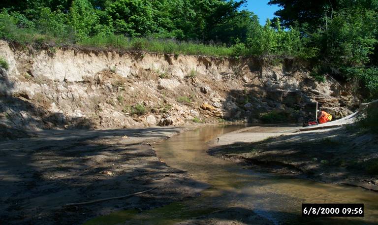
Little Topashaw Creek before construction.
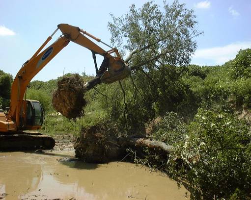
Construction of LWDs on Little Topashaw Creek.
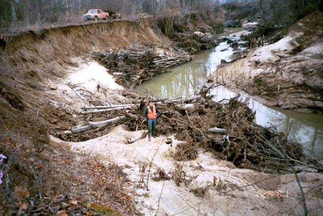
Bank shown in first photo above six months after construction.