TECOLOTE CANYON

TECOLOTE CANYON |
|
Project Name: Tecolote Canyon
Client/Project Owner: The City of San Diego
Project Designer: Carol L. Forrest, P. E., Woodward-Clyde
Technique(s) Demonstrated: Vegetated Gabions Baskets and Vegetated Riprap.
Geographical Location: This project was located in Tecolote Canyon Natural Park, a natural park owned by the City of San Diego. Tecolote Canyon is located in a semi-arid area and is drained by Tecolote Creek, which empties directly into Mission Bay.
Geomorphic Setting: Tecolote Canyon is located in a semi-arid watershed that receives approximately 24 cm (9.5 in) of rain, annually. The Tecolote Canyon watershed is 75% developed, with most of the development on the mesas overlooking the canyon. The development, which occurred primarily in the 1960s, increased the peak and average runoff volumes. This resulted in substantial erosion in Tecolote Canyon, and subsequent sediment deposition at the mouth of Tecolote Creek, in Mission Bay. The erosion in Tecolote Canyon was mostly due to gullying caused by storm water discharge from the mesas into Tecolote Creek, sheet flow and rill erosion on hillsides from the increased runoff from developed areas, and streambank and streambed deterioration from increased flow volumes. Tecolote Creek had incised through the alluvium in the canyon floor to bedrock. The creek was undercutting its banks, resulting in widening and dewatering of the channel banks, and riparian vegetation had died as a result of the drop in the water table.
Performance Period: 1987
Project Description: Tecolote Canyon had ongoing erosion problems that necessitated periodic dredging of Mission Bay to remove accumulated sediment. The U.S. Army Corps of Engineers granted the City of San Diego several dredging permits for Mission Bay, but eventually requested that the City improve its watershed management techniques in order to reduce the amount of sediment deposition in Mission Bay.
The City of San Diego studied the erosion issues associated with Tecolote Canyon, and developed this project to reduce those issues. Woodward-Clyde was selected to design and implement this project, which involved constructing a series of gabion weirs across Tecolote Creek and installing vegetated riprap along the eroding banks.
Before installation of the riprap, the banks were graded back, and granular fill was placed on the slope in lieu of filter fabric; this allowed root penetration into subsurface soils. Next, a layer of riprap, approximately one stone thick, was placed on the slope, covered with soil, seeded, and compacted to 90% with a sheepsfoot roller. This process of layering stone, soil, and seed was repeated until the riprap was level with the adjacent grade. The final structure was covered with soil and seeded but not compacted.
At the time of construction, the prevailing wisdom in riprap design was that any soil incorporated in riprap would be washed away and, therefore, should not be used. This project demonstrated that incorporating seeding and soil into riprap design could be effective in stabilizing riprap and increasing streambank habitat. A relatively large storm event occurred after installation; the riprap was inspected after the storm and there were signs of sediment deposition along the face of the structure, indicating that the soil used during construction was not being washed away.
In order to ensure that no further incisions of streambed or bank occurred, the flow rates in Tecolote Creek had to be slowed. Several gabion weirs were installed for this purpose, to act as check dams.
The sites for the gabion weirs were excavated and the base of the excavations was covered with filter fabric. Gabion mattresses were secured in the excavation site, and added to the weirs until they reached design dimensions. The filter fabric unfortunately prevented the establishment of vegetation and no vegetation was observed on the gabion weirs after six years of inspection.
The gabion weirs decreased flow velocities and raised the invert of the creek into the alluvium, allowing flows to recharge streambanks. The recharge of the streambank water table enhanced riparian growth along the banks and in the vegetated riprap. Large amounts of vegetation became established along the banks and bed of Tecolote Creek, which helped to further reduce flow velocities and enhance sediment deposition. The vegetation also decreased the capacity of the creek channel and increased flooding potential for the adjacent area, but as that area was natural parkland, it could serve as a floodplain for the creek, negating any detrimental effects associated with reduced flow capacity.
Photo Documentation:
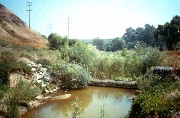
Vegetated riprap and gabions after first storm event.
Note deposition of
sediment on riprap.
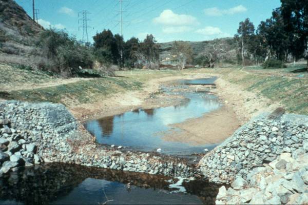
Gabion weir and vegetated riprap six years after construction.
Note that filter fabric was only used under gabions, and the gabions did not revegetate.